Timeline of the Chateauguay Region |
Return to Home Page/Retour ŕ la page d'accueil
 Today...
Today, this area is largely a rural farming area. Dairy farming is the principal
activity, although there are many apple orchards along the U.S. border. Many farmers grow
sweet corn, peas and beans for the Green Giant/Pillsbury cannery at Ste Martine. There are
also textile plants in Huntingdon and Ormstown.
The MRC du Haut-St. Laurent (regional council) now takes in 15 municipalities in the
Chateauguay River Valley, but the total population is only around 22,000. Some of the
municipalities are quite small. Dundee (65.82 sq. km.) had a population of 382 in 1991.
Elgin (70.07 sq.km.) had 469 residents. Probably 70% of the residents are French speaking.
The further east you go, the more you find residents who commute to Montreal to work.
Description as kindly provided by Alex Wilson, a resident of
Huntingdon
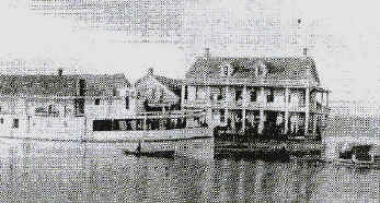
Early 20th Century photgraph of International Hotel, Dundee, Quebec, courtesy
of Bruce Tyo, Rochester, NY
How it developed...
The following notes were kindly provided by
Denice Lucas, as extracted from the book, The History of Huntingdon County by Robert
Sellers.
| 1764 |
The settlement began with the lands along the river from the "bridge west to
the rapids. North of the Chateaugay (sic) River to the St. Lawrence, 1542 Arpents
had been assigned. South of the Cateaugay River, 2875 Aprents had been
assigned." [Note: Sellers is consistent in using the phonetic spelling of
"Chateaugay" even referring at one point some dispute over the proper spelling
of...] |
| 1769 |
The Grey Nuns of Montreal build the first dam a short distance above the bridge
and also provided a grist mill. |
| 1774 |
The nuns build the present manor house. Settlement was largely at the mouth of the
Chateaugay River. There was very little movement toward the south.
|
| 1770 |
Beauharnois or Villachauve was developed. Land set apart for this was said
to be 18 miles square. |
| 1795 |
The seignoriers were sold to Alexander Ellice ( a member of a great commercial
house in London) for 36,000 Spanish dollars. |
| 1800 |
Ellice commissioned Francis Winter (America) and William Waller to do a general
survey of the entire area at which time it was subdivided into 10 (11?) sections, each
section being named for the Ellice children. Those sections are:
Catherinestown; Helenstown; Marystown, Annstown; North and South Georgetown; Ormstown,
Jamestown; Williamstown; Edwardstown; Russeltown (Now Franklin). Ellice named the
entire seignoiry for his wife Ann, calling it Annfield. Beauharnois was then known
as Annstown. Sellers comment: "Between the seignoiries and the frontier lay
vast wastelands. Chateaugay and Beauharnois occupied the greater part of the
wedge-shaped piece of land west of Caughnawaga." |
| 1788-1799 |
Deputy surveyor-general (Mr. Chewett) defined the boundaries of non-fief land west
of Richelieu (river) which constitutes the present county of Huntingdon, its singular
shape arising from its being formed of the gores left by seigniories. |
| 1791 |
The Canada Act instituted the English plan of counties and townships. |
| May 1792 |
Quebec was formed into 21 counties. The district lying west of Richelieu became a
large county which took in the seignieries. The townships/subdivisions were then
named for areas in Old Huntingdon, such as Hemingford, Godmanchester, Hinchingbrook.
This land was intended to be divided among the veterans of the American War, especially
large parts of Godmanchester and Hinchinbrook (Sellers goes on to explain the
variant spelling of some of these names, i.e. Hemingford become Hemmingford, Hinchingbrook
become Hinchinbrook). |
Return to Home Page/Retour ŕ la page d'accueil
E-Mail: Ken
Steffenson
Page Last Modified: 18/11/23